This is part of an ongoing series to identify inefficient bus routes.
Hanoi, Vietnam has plenty of useful transit routes, including a brand new metro line with lots of expansion potential. And while the Hanoi Bus Rapid Transit (BRT) system isn't completely useless, it is certainly an honorable mention. And it's a shame, too.
There are certain things that must be present for true BRT. Hanoi does not check any boxes.
❌
Dedicated Lanes
❌ Signal
Priority
❌
Enhanced Capacity
❌ Ease
of Access
✅ Frequent
✅ Branding
BRT "Lite", which North America loves, can check some of these boxes. It's important to emphasize that Hanoi BRT checks very few.
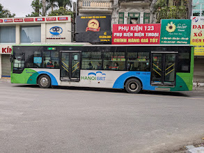
Hanoi BRT bus
It has nice a nice paint job, and comes at a somewhat frequent interval (not great, but acceptable). The simple question: is Hanoi BRT really BRT? Is it even BRT Lite?
As I've touched on, making transit more friendly with good design and branding is critical to creating a safe and welcoming space for riders. It creates an environment that people actually want to go back to, and don't mind staying in. Maybe - just maybe - they will even be more tolerant of an occasional system delay when they aren't waiting in an unwelcome environment.
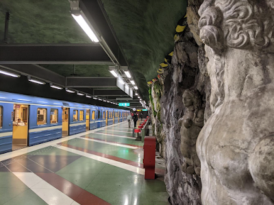
Stockholm understands this perfectly, as most of their metro network is essentially an art gallery
More artwork in the beautiful Stockholm Metro
It doesn't take effort to make the environment more welcoming. In Stockholm's case, the gold standard for transit art, it actually costs money in the form of paint, sculptures, artwork, etc. Not all stations are completely decked out with art, however.
A little bit of paint can go a long way
If spending money on art is a problem, maybe consider a second screen for a bus that is out of service. The bus could read "out of service", and then flash to "Thank you Veterans" on veteran's day.
Chicago, IL CTA bus with some holiday graphics
"Welcome Aboard" on a bus in Denver, Colorado. Why not?
Of course, there are things you probably shouldn't do, as well. Avoid displaying rules or nagging messages.
Be careful what rules you post on the outside of a bus unless you are certain you will enforce it 100%
Whenever we drive our cars, we have the option to keep noise to a minimum. Should we choose not to, we can turn the radio on, open a window, or have a conversation. Cars are contained bubbles of our own, and we should expect that rail can be a peaceful experience as well.
Some systems are obnoxiously loud, seemingly blaring announcements at all times. Few of these announcements are necessary, and it is a stretch to say that they reduce liability for a system or educate the public when they continuously speak to us. More than likely, they simply create noise pollution and create indifference toward the announcement system as a whole. For example, do you ever pay attention to the airport announcement system? I've been to "quiet airports" around the world, and they're a far more relaxing and pleasant experience.
Trains are no different, and many rail systems even have "quiet cars". Even my beloved Hong Kong MTR is riddled with announcements (although this is in part due to being polyglot - example below).
On weekdays, the front car of the New Mexico Rail Runner is the designated quiet car (and a really great paint job).
A Japan Railways (JR) "Green Car" on the left, with a regular car on the right. Green cars are special quiet cars.
Not everyone gets this memo. I recently rode just six stops on Portland, Oregon's light rail system and quickly became inundated with worthless announcements:
Before every departure
The doors are closing. Train departing. Please hold on.
Before every arrival
(Station name). Doors to my left (right). Puertas a mi izquierda (derecha).
At a major station I passed through
Interstate Rose Quarter, Moda Center, and Veteran's Memorial Coliseum. Doors to my left. Transfer to blue, green, and red line trains by walking one block east. Always use crosswalks and look both ways before crossing tracks.Puertas a mi izquierda. Transbordo a los trenes de líneas azules, verdes y rojas a una cuadra al este. Siempre use los pasos de peatones y mire a ambos lados antes de cruzar las vías.
When the doors opened at the major station
Orange line to Milwaukie. Línea naranja a Milwaukie.
Other announcements heard:
In the priority seating area, you are required to move for seniors and people with disabilities. En el área de asientos prioritarios, se le requiere que se mueva para personas mayores y personas con discapacidades.
Always use crosswalks and look both ways before crossing tracks. Siempre use los pasos de peatones y mire a ambos lados antes de cruzar las vías.
Be alert and stay safe. Report suspicious objects or behaviors to a TriMet employee, or call 9-1-1. Estar alerta y mantenerse a salvo. Reportan de objetos sospechosos o comportamientos a un empleado de TriMet, o llame 9-1-1.
The above text in six stations is already around three hundred words. Some of them make the system great, and others are simply white noise.
Let's break it down.
First, eliminate all of the "Other" announcements. They don't add any value whatsoever. They would work just fine as a sign.
"If you SEE something, SAY something" sign on the New Mexico Rail Runner.
Next, treat the major station the same as a regular station. If you have to announce that the transfer is "one block east", then your off-train signage is terrible and you've failed as a transportation system.
Eliminate door closing rambling. Most systems around the world simply have flashing lights and/or a minor chime. "The doors are closing. Train departing. Please hold on" is too long and loaded with obvious and unimportant information. The door chime could just as easily be "Doors close. Trains move. Force equals mass times acceleration."
The New Mexico Rail Runner door chime is a spectacular and creative branding example
Add an announcement for the line color and destination for each stop. "Orange line, línea naranja, Milwaukie" should be added to each station, not just transfer points. This makes the system more friendly and it is precisely the right amount of useful information to share. It's also great to eliminate extra words whenever possible. In the Seattle area, Sound Transit's Link makes it a habit to say "station" after each station announcement, i.e. "Tukwila International Boulevard Station." We know it's a station... you don't have to tell us.
If a system is going to inform its riders of the rules, there is a time and place for it. Although I see no reason to do so under nearly all circumstances, there can be more tasteful examples of announcements.
One of Hong Kong's MTR announcements in Cantonese, Mandarin, and English
One final thought: a system's cleanliness and design should make it difficult to break the rules to begin with. Priority seating areas should be very clearly labeled, signs and wayfaring should be excellent, and fares systems should be easy to adhere to. However, there will be more on system and station design in the future.
Great map to reduce announcements. What would happen if the Budapest Metro announced every connection?
This is part of an ongoing series to identify inefficient bus routes.
Every year, Streetsblog has a "competition" (2017 link) to find the sorriest bus stops in the country. It's a competitive title in America to be sure. I would like to propose another category to the mix: sorriest bus lines in the country.
For me, there are two that stand out as particularly useless (again, it is a very competitive title and I will continue to keep watch for additional contenders). These bus lines makes so little sense that I would rather adopt the Rankine scale for daily temperature measurement.
Here are just a couple I have stumbled across. Note that public transport in the Untied States is considered public welfare and not public good; therefore, limited resources are routinely spent to direct buses where they have no business going.
C-Tran in Vancouver, Washington
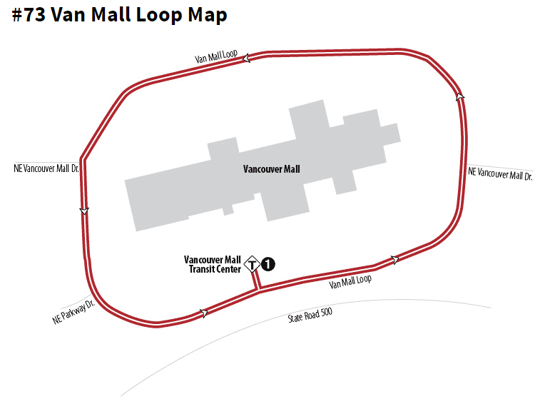
This is a real bus route. It is about 2km long.
C-Tran operates a bus route that is essentially a ~10-times-daily parking lot shuttle. Most runs carry zero or no passengers. The entire route consists of circling a mall parking lot.
For what it's worth, the bus circle starts operating bright and early.
The area where C-Tran's unused, taxpayer funded parking shuttle is surrounded by an ocean of asphalt.
I reached out to C-Tran to ask why this route existed. The response was essentially as I expected: politics, social welfare, and fear of resources being siphoned to more expensive paratransit rides (a topic worth covering in depth for an entire blog post).
The email response from Jim, C-Tran's Director of Operations:
Thanks for asking Nicholas.
We developed Route 73 after hearing from several riders who live in the residential area just north of the Mall. They came to a board meeting and asked that we not move the transit center to the south side where it is today. Knowing we had to move, we thought a route looping around the Mall would continue to serve these riders. As you've observed, there are very few taking advantage of this service. If ridership does not grow on this route, it will likely be eliminated. We'll see what happens over the next few months. Thanks again, Jim
ABQ Ride in Albuquerque, New Mexico
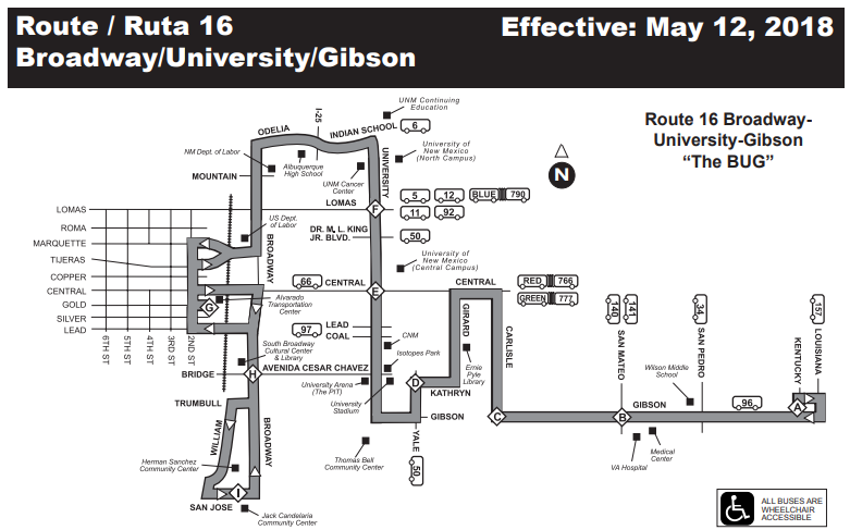
The "BUG" bus, which also holds the title for "worst bus name".
The route looks like someone was trying to carve their initials into the city. Rather than "driving in circles", the route "drives back and forth". Hardly much better.
Albuquerque isn't know for having superb bus service (yet, anyway). Unlike C-Tran, which is apparently considering the elimination of a useless bus route, ABQ Ride has no intention to do so. However, this route actually does see ridership that can only be described as completely transit-dependent people.
Some ABQ Ride buses in downtown Albuquerque, where route 16 forcefully veers off route to go.
A sad route 16 bus stop along a busy, high speed road (though, due to construction, it was reduced to only 35mph!).
ABQ Ride route 16 is actually a blending of routes 16 and 18 (which was discontinued) due to budget constrictions. While both routes suffered from low ridership, it's difficult to believe that anyone on the right side of the map would ever take this bus to anywhere on the left side. It would be faster simply to walk.
As I have hinted previously about route maps, I expect this to be a regular thing. There are just too many examples, especially in small towns where buses operate along squiggly lines. Then again, they serve a very different purpose in small towns.
Note: The world has many words for its fascination with motorways, freeways, interstates, highways, expressways, autobahns, carriageways, autoroutes, and more. These are all assumed the same in this post.
Which is better: a street with no sidewalks, or a street with a sidewalk on every-other block? Or, is having a sidewalk every-other block no better than having none at all?
Let's talk grade separation.
One of the reasons that freeways are fast, efficient, and have such a high vehicle flow rate is because of their complete lack of interruption. They are free ways; they operate freely without other modes of transportation or crossings. In short, they have controlled access which also bans non vehicular modes of travel from entering, except at designated locations.
Overpasses are another prime example of keeping traffic separated
We're all told when we are young to look left-right-left (or right-left-right, for left-side driving countries) before we cross the street. What is it that makes this necessary? The short answer: inefficiency. If you eliminate the road or provide a bypass/overpass/underpass, there is no need to stop, wait, and look both ways before crossing the street.
Transit, meanwhile, requires the same level of separation for similar efficiency to be achieved as freeways. Traffic can flow freely without interruption (aside from congestion due to insufficient capacity) whether you are on road or rail, provided it is dedicated its own right of way.
This holds true regardless of where you are or how you are getting about.
This train sitting in traffic in Portland, OR is no better off than a bus or car sitting in traffic
Buses and trains in Portland, OR sharing space with cars, bikes, trucks, and pedestrians; this greatly slows the system down and makes it far less reliable
Often times, this is not a black of white situation. While transit sharing space with automobiles is one of the worst examples, it can be significantly more cost effective to operate trains over their own space on the surface. Usually, the most important thing that can be done is simply removing cars. However, one of the reasons metros (subways) are so effective is because they operate without interference. When passenger barriers are in place, as discussed in a previous article, transit doesn't even need to be concerned about pedestrian interference on platforms. This can be done with all modes of transit, even buses.
Casablanca, Morocco operates trams on surface streets which do not allow automobiles - only pedestrians
Grade separation is important for many reasons, including, first and foremost, reliability. It keeps transportation on-time and on-budget. I use the general term "transportation" here because this applies to freight and passenger vehicular traffic, too!
What if the Sydney Harbour Bridge had a lift for ships to pass under? What a mess that would be!
Any time you are suck waiting for a train at a grade crossing, think inefficiency
The primary cause for grade crossings, whether you be at a red light, on a train, or floating on a river is one of cost. It is very expensive to untangle modes of transportation. Airplanes tend to be the mode of transportation entirely grade separated, except for a few places (Gibraltar's airport, for example, mixes airplanes and cars).
In general, the more dedicated right of way you have, the faster, safer, and more efficiently you will get to where you are going.
High speed trains, like Russia's Sapsan, operate just as a car on a motorway would - fast and reliably
It is obvious: there are too many missed opportunities around the world for creating a connection between people and the way they get around. No one drives an unpainted car or keeps it completely sterile of character. How we travel is intimately a part of us, and inescapably so.
It is time for "good example, bad example." On human connections, the good: Rio de Janeiro, Brazil
"It's really good to have you with us every day. Thank you..." sign in Rio de Janeiro. Photo from Google Street View
On human connections, the bad: Rome, Italy
Sorry, Rome. Your graffiti trains don't count as a human connection.
On branding and logos, the good: South Africa
PRASA's (Passenger Rail Agency South Africa) "Shosholoza Meyl" long distance train. The name holds special meaning in South Africa.
Shosholoza Meyl, aside from a meaningful name and visually unique paint job, also has one of the best transport logos in the world.
On branding and logos, the bad: anywhere with metallic trains
Looking at you, CityRail (Sydney, NSW, Australia). It's not possible to tell what this is from the outside, besides a train of some kind.
Nice try, MTA (New York City, New York, United States). The American flag does not count as unique transport branding no matter how many times you paste it on a carriage.
At least put a little effort in. Give it character. Make it an experience and a pleasant life choice. If it's a joy to ride and people can be proud of it, the system as a whole will prosper.
You have, again, read the heading correctly. Like in my last post, the United States has one of the best bus systems in the world.
Fast: Many buses operate express or limited
Frequent: Buses can operate around every minute or two during peak times
Easy to use: All stops are clearly marked, have passenger queues, and distinct, helpful signage
Crimeless: You can bet there is a zero tolerance for shenanigans.
Span: The system operates virtually around the clock, and at high frequency for as many as 20 hours a day.
Free*
*Here is where my game is up. It is only free to Walt Disney World customers and employees, not that it is really useful for anyone else.
Disney Transport, owned by the Walt Disney Company, operates around Orlando, Florida. The bus system operates alongside a network of monorails, people-movers, and boats. It was said to me, although I could not independently verify (and don't try it), that Disney Transport will dispatch a bus to your location if you ever find yourself stranded. This is a critical "lifeline" service that only a handful of bus systems in the United States use, if it does indeed exist. However, with such an impressive service span, it is unlikely to be utilized. Offering such a service is an important thing for any system that wants to overcome a barrier of transit: "Can I get home no matter what?"
Disney Transport is the greatest bus system in the United States
A typical crowd pleaser for the far right, it is also worth noting that the system operates entirely without subsidy, with the exception of a few roads that the buses operate on. One could also say that because of Buy America, taxes, and things like the GM government bailout, there are a few other strings attached to that statement, but more on vehicle subsidies another time.
At least one part of the United States understands how important a robust, total transportation system is. If it brings such a great amount of value to a private company (and to a level where they foot the bill themselves), imagine what it could do to an entire city? State? Country?
You have read the heading correctly. This is no trick; the United States has some of the best rail systems in the world.
What do I mean when I say the best?
Fast.
Frequent.
100% grade separated (including from passengers - I reviewed passenger gates on a previous post).
Easy to use.
Electrified.
Crimeless.
Free (some of them!)
There aren't just one of these systems in the United States... there are actually many. And nearly all of them have these characteristics.
Okay... so I may have omitted one detail. These trains are technically "Light Metros" or "People Movers", and all the ones worth mentioning exist at airports. Miami and Detroit have them, but they do not serve much of a transportation purpose. Newark, New York, Chicago, San Francisco, Seattle, Denver, Dallas, Houston...
Entry to Denver International Airport's train
Just imagine what the United States would look like if railway networks were taken half as serious as airport trains. One of these systems even excels at uniquely conveying a meaningful message to its passengers: Denver International Airport (DIA) has a train uniquely branded with music at each station.
DIA's train departing from a station
DIA's train has clear messaging, up-to-the-minute arrival information posted (trains depart every 2-4 minutes), and total grade separation from passengers. The system operates 24 hours a day.
Although no ridership statistics exist as far as I am aware, I would bet that ridership is much higher on a single airport transit system (at one airport) than on the entire Amtrak national rail system. What does this say about national priorities?
Back in my transit days, I worked with all kinds of diversity. It was truly great: bus riders that were old and young, educated or not, eco-conscious or thrifty, poor or otherwise, all in various mental states. It was truly a pleasure and one where I found myself continuously in my element while at the same time being on the edge of my seat in preparation for the unexpected all at once. Then, in the late 2000s and early 2010s, the recession hit. It was time to cut transit service.
How can such a thing be accomplished? What goes and what stays? Countless late-night meetings, public input sessions, and comment database entries later, a decision had to be reached to plug a growing financial gap from a deep recession.
The pyramid of transit in North America
"We should cut the hours of Bus 10, because it's redundant." "Let's reroute the Buses 11 and 12 to cover the areas of the 10 that we lost." "Let's eliminate the 14 - no one ever rides it anyway." All of these are examples of the priorities that an agency with a limited pot of money can choose to allocate its resources to.
Coverage:
Question: Do we want to serve as many places as possible, even if the frequency is poor?
Example: Should we operate buses on rural routes?
Ridership:
Question: Do we want to make sure that the areas with demonstrated demand are adequately served?
Example: Should major corridors remain at high frequency, possibly with limited, express, or skip-stop service?
Need:
Question: Do we want those with mobility challenges or those with an economic disadvantage to have fair, equal, and/or adequate access to service?
Example: Should a bus detour to serve a large retirement community, even if it adds time to a schedule and/or ridership is not high?
There are no right answers here
These questions are ethical and morale decisions that all agencies face. The answer is clearly "Yes!" to all of them, but no agency is able to provide a ridership-based, need-responsive, wide-coverage area of service on a budget. In the perfect world, a transit provider would be able to say to its government, "This tram, bus, or train is full. We should add another..." but this isn't always the case. And so, we must compromise and hash out our values.
Perhaps your agency, whether it be a board of directors, citizen committee, or otherwise, chooses to weigh its service 20/20/60. 20% of the service budget for Coverage and Ridership, 60% for Need. Or, to put it another way, $60 of every $100 of service will be designed to serve those with the greatest need for transit.
Perhaps you prefer something else; maybe you'd like to maximize ridership and therefore you focus on core corridors with no deviations and a frequent, skip-stop, 24-hour service: A real 10/80/10 breakdown.
A real agency would never have something as extreme as 100/0/0 (maximum Coverage), because that would mean something crazy like one bus, once per day, down every single road in the entire metropolitan area: truly maximum coverage.
There is no good ending when transit service is cut. At the end of the day, no one was happy with the decisions that were made.
This article deals primarily with Portland's transit agency, the Tri-County Metropolitan Transportation District of Oregon (TriMet), using basic transit simplicity.
Everyone understands a line. It is the shortest distance between two points. Roads often travel in lines, and buses run in lines. Except when they don't.
This is a real transit map, located on a bus stop pole. It is supposed to explain to you where a bus travels.
Where does line 1-Vermont travel to, and how does it get you there? Where is "Maplewood," which doesn't appear on the map? When bus lines drive in circles, it's hard to think of an easier way to confuse riders. As an experienced transit rider, I immediately have the following questions:
Which loop does this bus travel on first?
Is each loop served in the same frequencies and times, or does it vary by time of day?
Which direction does the bus travel in the loops? Does this reverse during evening and afternoon rush hours?
Is it faster to walk than to take this bus?
This bus route looks like a catch-all route that was designed as lifeline and essential commuter service for a small group of vocal and/or exceptionally needy individuals. This an important part of the trifecta of transit, which is essential enough to merit its own post at a later date. One final question to draw from this map: where does the bus start and end?
This is hardly an isolated example of trying to cram too much information about a complex system in to a small space.
So... when does it run?
Runs every day? Runs once per day? Runs every weekday? This statement is ambiguous as it is pointless. When is the first bus? The last bus? What is the frequency? More questions are asked than answered by such a statement.
Transit aficionados have heard the saying "frequency is freedom". However, there is a point when frequency becomes too frequent and the system simply fails to provide better service by adding an additional bus to serve a line. This is nearing that point:
This line is leapfrogging.
Each bus is held up in traffic, stuck behind the bus in front of it. The buses are unable to proceed more than one stop in front of the other without delaying the one behind it. Essentially, this is a negative feedback loop, and it is very common when agencies "throw more buses" at the problem of high demand. In this case, we are nearing peak rush hour. More service isn't adding anything.
Here is a simple solution: create a higher level of service. Instead of operating the line (in this case, Bus #12) every 3-4 minutes, operate it instead every 6-7 minutes. Then, create a parallel line. This new line, the 12L or 12E (Limited or Express) can serve less stops and provide a higher level of service.
This is the basic principle of the slow evolution to Bus Rapid Transit (BRT).
Lessons from TriMet, Part 2: Rail will be posted at a later date.
As discussed in my previous post, Human Connections and Jingles, a large complaint with North American public transport is how unfriendly and complicated it is (or seems to be).
"Thank you for choosing public transport," an obvious indicator you are at a station. Montréal, Québec
This goes beyond simply thanking and acknowledging your riders, however. To attract choice riders (what I would say is an indicator of a robust transit network, but more on choice riders another time), people must be able to decipher first and foremost how to get where they are going.
Many writers have already commented on the concept of "total transit", which takes in to account the full experience of riding starting the moment when you leave your home. An equal number have discussed transit planning, mapping, and the importance (or requirement, really) of frequent service intervals for transit to be useful. Instead, there is hybrid aspect that is more subtle in the design of networks and their user-friendliness. It's so simple that it is often overlooked.
Metrobús, Ciudad de Panamá, Panamá
Examine the image above, and then take in to consideration my duo of primary criticisms.
1) There is no indication that the bus stops here. This is as much a failure of branding as it is of transit. Bus stops (or tram stops, etc) can be free advertisement for a system. Without Google Maps, I would have been clueless where to catch this bus.
2) Worse yet, the display on this bus is useless. Many of the buses in Panama either use Corredor Norte (North Corridor) or Corredor Sur (South Corridor), two main highways. At first glance, you have no idea what line this is (there is no number, letter, or color assigned to it). If you wait a few seconds, it will flash "TOCUMEN", and then return to "CORREDOR SUR". Whether or not this means the district of Tocumen or Aeropuerto Internacional de Tocumen (Panama's largest and primary airport) is any new riders' guess. Spoiler alert: this does actually go by the airport.
At least this sad bus stop in Albuquerque, New Mexico gives you a number and a destination (sort of).
This problem of visual identity is primarily a bus network problem, but not always.
A Belgrade tram operated at grade. Photo by SO Marissa
Many European cities still have this layout with old tramways located in the median of streets. Many Trams in Eastern Europe operate down the center of roads and open their doors to traffic, generally with little or no signage at major intersections. Side note: this can have a traffic calming effect!
The point is this: you should be able to at least tell where the transit stops are at. If you cannot, then the system has failed.
Minimum: there should be some kind of identifiable station. It should be well branded. And to excel and truly be a world class system, the branding should be meaningful.
Hong Kong MTR (Mass Transit Railway) sign inside a station.
You do not need to be flashy, you just need to make the system human. And, because transit is a more human (and healthy!) way to travel, this should be easy.
If you're travelling anywhere on public transport and you see on a map that there is a "transit center", what does it mean?
This may seem like a simple and uninteresting question (simple to most, yes; uninteresting to all but transit geeks, probably). While no particular definition exists, I could easily make some assumptions if you were to state you were at one. First, I'd immediately assume you were in the US or Canada. This is because I have never heard of a transit center anywhere outside of North America outside from a different name for "central station" here or there. And just exactly how would you describe a transit center to someone else?
Is it a point where one line meets another? Two? Where's the line to draw between a simple transfer point and this mythical place called a "transit center"?
Tokyo would have more transit centers than anyone else. Image source: Tokyo Metro
Perhaps it comes down to amenities: toilets, shops, shelter, etc. Maybe it comes down to frequency: at any point, you're going to see a transit vehicle (or two, three, or ten). One thing that all transit systems seem to have in common who use this terminology is that they all seem to be low-frequency, slow, and inconvenient systems. In other words, they're in places with poor transit. They're used to make a system sound more friendly and important than it really is.
This is a "transit center" in Portland, Oregon. More info here.
What is a transit center? Whatever you want it to be.